搜索结果: 1-15 共查到“测绘科学技术 Underwater”相关记录43条 . 查询时间(0.093 秒)
DIVERS-OPERATED UNDERWATER PHOTOGRAMMETRY: APPLICATIONS IN THE STUDY OF ANTARCTIC BENTHOS
Benthos 3D models video samplings diver-operated underwater photogrammetry Antarctica historical videos 3D features detecting
2018/6/4
Ecological studies about marine benthic communities received a major leap from the application of a variety of non-destructive sampling and mapping techniques based on underwater image and video recor...
MONITORING CORAL GROWTH – THE DICHOTOMY BETWEEN UNDERWATER PHOTOGRAMMETRY AND GEODETIC CONTROL NETWORK
Underwater Geodetic Network, Photogrammetry Underwater 3D Model Coral Growth Monitoring Change Detection Deformation Analysis
2018/6/4
Creating 3-dimensional (3D) models of underwater scenes has become a common approach for monitoring coral reef changes and its structural complexity. Also in underwater archeology, 3D models are often...
IMPROVING UNDERWATER ACCURACY BY EMPIRICAL WEIGHTING OF IMAGE OBSERVATIONS
underwater photogrammetry, image quality, bundle adjustment, image observation weighting
2018/6/4
An underwater imaging system with camera and lens behind a flat port does not behave as a standard pinhole camera with additional parameters. Indeed, whenever the entrance pupil of the lens is not in ...
UNDERWATER PHOTOGRAMMETRY IN VERY SHALLOW WATERS: MAIN CHALLENGES AND CAUSTICS EFFECT REMOVAL
Underwater 3D Reconstruction SfM MVS Caustics CNN
2018/6/4
In this paper, main challenges of underwater photogrammetry in shallow waters are described and analysed. The very short camera to object distance in such cases, as well as buoyancy issues, wave effec...
LOW COST EMBEDDED STEREO SYSTEM FOR UNDERWATER SURVEYS
Image processing underwater imaging embedded systems stereo vision visual odometry 3D reconstruction
2018/3/6
This paper provides details of both hardware and software conception and realization of a hand-held stereo embedded system for underwater imaging. The designed system can run most image processing tec...

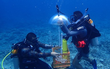
In Guam, researchers developed a method for mapping underwater areas that is transforming how oceanographers observe the seafloor. Data from global positioning satellites are the primary method for ma...
TOWARDS GUIDED UNDERWATER SURVEY USING LIGHT VISUAL ODOMETRY
Visual odometry underwater imaging computer vision
2017/4/10
A light distributed visual odometry method adapted to embedded hardware platform is proposed. The aim is to guide underwater surveys in real time. We rely on image stream captured using portable stere...
VIRTUAL DIVING IN THE UNDERWATER ARCHAEOLOGICAL SITE OF CALA MINNOLA
Virtual Reality virtual exploitation underwater 3D reconstruction Underwater Cultural Heritage
2017/4/5
The paper presents the application of the technologies and methods defined in the VISAS project for the case study of the underwater archaeological site of Cala Minnola located in the island of Levanz...
COMPARISON OF COMMERCIAL STRUCTURE-FROM-MOTION PHOTOGRAMMETY SOFTWARE USED FOR UNDERWATER THREE-DIMENSIONAL MODELING OF CORAL REEF ENVIRONMENTS
Coral Reefs Coral Ecology Habitat Photogrammetry Structure-from-Motion Structural Complexity 3D topographic reconstruction 3D underwater modeling Agisoft Photoscan Pix4D
2017/4/5
Structural complexity in ecosystems creates an assortment of microhabitat types and has been shown to support greater diversity and abundance of associated organisms. The 3D structure of an environmen...
THE EFFECT OF UNDERWATER IMAGERY RADIOMETRY ON 3D RECONSTRUCTION AND ORTHOIMAGERY
Underwater 3D Reconstruction Underwater Image Enhancement
2017/4/5
The work presented in this paper investigates the effect of the radiometry of the underwater imagery on automating the 3D reconstruction and the produced orthoimagery. Main aim is to investigate wheth...
2017IEEE OES国际水下技术研讨会(IEEE OES International Symposium on Underwater Technology)
2017 IEEE OES 国际 水下技术 研讨会
2017/1/18
The 10th international symposium on Underwater Technology 2017 (UT17) will be held in Novotel Ambassador Hotel, Busan, Korean from February 21-24, 2017. The first international symposium on underwater...
ACCURACY ASSESSMENT OF UNDERWATER PHOTOGRAMMETRIC THREE DIMENSIONAL MODELLING FOR CORAL REEFS
Photogrammetry Underwater 3D Modelling Accuracy Assessment Calibration Point Clouds Coral Reefs Coral Growth Moorea
2016/11/11
Recent advances in automation of photogrammetric 3D modelling software packages have stimulated interest in reconstructing highly accurate 3D object geometry in unconventional environments such as und...
ACCURACY ASSESSMENT OF GO PRO HERO 3 (BLACK) CAMERA IN UNDERWATER ENVIRONMENT
Calibration underwater action camera lens distortion quality assessment
2016/11/11
Modern digital cameras are increasing in quality whilst decreasing in size. In the last decade, a number of waterproof consumer digital cameras (action cameras) have become available, which often cost...
UNDERWATER 3D MODELING: IMAGE ENHANCEMENT AND POINT CLOUD FILTERING
Underwater Photogrammetry 3D Modeling Image Enhancement
2016/7/8
This paper examines the results of image enhancement and point cloud filtering on the visual and geometric quality of 3D models for the representation of underwater features. Specifically it evaluates...
UNDERWATER CALIBRATION OF DOME PORT PRESSURE HOUSINGS
Underwater Photogrammetry Camera calibration Decentring distortion
2016/3/25
Underwater photogrammetry using consumer grade photographic equipment can be feasible for different applications, e.g. archaeology, biology, industrial inspections, etc. The use of a camera underwater...

