搜索结果: 1-15 共查到“摄影测量与遥感技术 ISPRS”相关记录40条 . 查询时间(0.14 秒)

陈军院士当选国际摄影测量与遥感学会(ISPRS)荣誉会员 并在第24届ISPRS(图)
摄影测量 遥感学 ISPRS
2024/12/19
2022年6月6日,第24届国际摄影测量与遥感大会(简称ISPRSCongress)在法国尼斯拉开序幕。陈军院士当选国际摄影测量与遥感学会(ISPRS)荣誉会员并在第24届ISPRS大会做主旨报告。
中国测绘学会推荐多位专家竞选ISPRS高级职位
国际摄影测量 遥感与空间信息技术
2022/9/13
国际摄影测量与遥感学会(International Society for Photogrammetry and Remote Sensing,以下简称为“ISPRS”)是一个以推动国际摄影测量、遥感与空间信息技术的发展、应用与交流合作为宗旨是国际学术组织,成员遍及近200个国家和地区,具有学术活动历史悠久、参与面宽、影响力大等特点。

电子科技大学资源与环境学院定量遥感团队在《ISPRS Journal of Photogrammetry and Remote Sensing》发表研究成果(图)
电子科技大学资源与环境学院 定量遥感 热红外 遥感信息处理 参数反演
2020/8/6
近日,我校资环学院定量遥感团队周纪课题组在卫星被动微波与热红外遥感信息处理和参数反演方面取得重要研究进展。他们在遥感领域顶级期刊《ISPRS Journal of Photogrammetry and Remote Sensing》(一区期刊,影响因子7.319;为国际摄影测量与遥感协会ISPRS会刊)发表了题为“Estimation of 1-km all-weather remotely se...

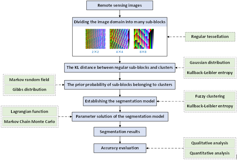
近日,国际摄影测量与遥感学会(ISPRS)正式通知,中国科学院深圳先进技术研究院数字所空间信息研究中心中心李晓丽博士凭借与博后导师陈劲松研究员合著的论文"Region-Based Fuzzy Clustering Image Segmentation Algorithm With Kullback-Leibler Distance",获2020年度国际摄影测量与遥感学会最佳青年作者奖(ISPRS ...

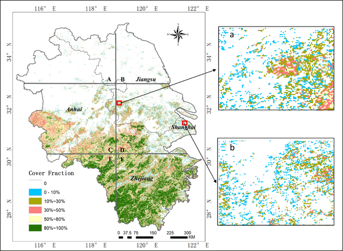
地学院测绘系18级博士生杨莹莹同学论文‘Fractional evergreen forest cover mapping by MODIS time-series FEVC-CV methods at sub-pixel scales’被一区期刊 ISPRS Journal of Photogrammetry and Remote Sensing接收发表,基于中等分辨率遥感时间序列数据实现了大尺...
首届ISPRS大气遥感与协同分析研讨会在中南大学举办
ISPRS 大气遥感 研讨会 中南大学
2017/10/25
2017年9月21-22日,由中南大学测绘学科与国际摄影测量与遥感协会大气环境遥感工作组(ISPRS WGIII/8)共同组织的首届ISPRS大气遥感与协同分析研讨会(简称ISPRS RSAE)在长沙召开,来自德国、美国、澳地利、中国香港等国内外25家单位的80余位代表参与了本次会议,我校测绘学科带头人、长江学者吴立新教授担任大会主席,邹滨副教授担任大会副主席。大会开幕式由大会主席吴立新教授主持。...
FOSS4G DATE ASSESSMENT ON THE ISPRS OPTICAL STEREO SATELLITE DATA: A BENCHMARK FOR DSM GENERATION
Cartosat-1 Worldview-1 DSM Matching Accuracy FOSS4G
2017/7/13
The ISPRS Working Group 4 Commission I on “Geometric and Radiometric Modelling of Optical Spaceborne Sensors”, provides a benchmark dataset with several stereo data sets from space borne stereo sensor...
The 2017 ISPRS Workshop on Cryosphere and Hydrosphere for Global Change Studies(CHGCS 2017)
The 2017 ISPRS Workshop Cryosphere and Hydrosphere for Global Change Studies
2017/4/26
Earth’s climate is changing, and multiple lines of evidence suggest significant warming in the cryosphere, the oceans and the atmosphere. The global surface temperature is increasing, the global sea l...
2017ISPRS摄影测量三维重建与地学应用研讨会(ISPRS Geospatial Week Workshop Photogrammetric 3D Reconstruction for Geo-Applications 2017)
2017 ISPRS 摄影测量三维重建与地学应用 研讨会
2017/4/26
PhotoGA 2017 provides an opportunity and platform for all professionals involved in photogrammetric 3D reconstruction to share research ideas and results, foster and enhance cooperation, draw inspirat...
Indoor3D is the latest in the series of workshops dedicated to research and developments in the area of indoor spatial information. Indoor 3D 2017 aims to bring together researchers and practitioners ...
2017ISPRS SAR前沿发展国际研讨会:星座,信号处理和应用(The 2017 ISPRS International Workshop on Advances in SAR:Constellations,Signal processing,and Applications)
2017 ISPRS SAR前沿发展 国际研讨会 星座,信号处理和应用
2017/4/25
The key importance of radar remote sensing for civil applications has been recognized for decades, and enormous scientific and technical developments have been carried out to further improve the SAR s...
Indoor3D is the latest in the series of workshops dedicated to research and developments in the area of indoor spatial information. Indoor 3D 2017 aims to bring together researchers and practitioners ...
ISPRS Workshop Indoor 3D 2017
ISPRS Workshop Indoor 3D 2017
2017/3/29
Indoor3D is the latest in the series of workshops dedicated to research and developments in the area of indoor spatial information. Indoor 3D 2017 aims to bring together researchers and practitioners ...
由国际摄影测量与遥感学会(International Society for Photogrammetry and Remote Sensing, 英文简称ISPRS)与武汉大学主办的ISPRS Geospatial Week 2017将于2017年9月18日至22日在武汉东湖国际会议中心召开。本次大会围绕“地理空间智慧城市—Geospatial For Smart City”的主题,大会第一天将...
LATEST DEVELOPMENTS OF THE ISPRS STUDENT CONSORTIUM
education student network young professionals student events and activities summer schools newsletter website
2016/11/15
The International Society for Photogrammetry and Remote Sensing (ISPRS) Student Consortium (SC) is a network for young professionals studying or working within the fields of photogrammetry, remote sen...

